
Pond Hopper
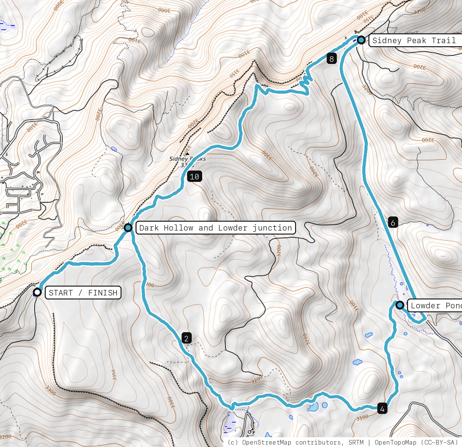
Sidney Peak Trail to the Dark Hollow junction, Lowder Creek singletrack past the Lowder Ponds, then Forest Service roads and the full Sidney Peak ridge back to the trailhead.
Your timesno timed runs yet
Ride mode times every run on its own: the clock starts when you roll out of the start and stops at the finish, with splits at each marked spot. Leave Ride mode on between laps and it re-arms when you're back at the start. Times stay on this phone.
Right now at the trailhead


Get the GPS file
Scan with a friend's phone, or tap below. Then open it in your ride app.
- iPhone: tap Download, open it from the Downloads bar, then Share → Trailforks, Strava or Garmin.
- Android: tap Download, then open the file and pick your app.
- Garmin: or drag it into Garmin Connect → Courses → Import on a computer.
https://bsqrd-designs.com/dirt/pond-hopper/
Getting there
Park at Brian Head Peak Trailhead (Sidney Peak trailhead)
Brian Head Peak Road (FR 047), off SR-143 near the summit, Brian Head, UT 84719
- Forest Service trailhead on the gravel road toward Brian Head Peak, with a pit toilet and no water. Small lot; arrive early on summer weekends.
- Start and finish are the same spot. Follow the cue sheet and the arrows on the map.
Cue sheet
| 0.0 | Sidney Peak Trailsingletrack | 1.1 mi |
| 1.1 | Lowder Creeksingletrack via Lowder Ponds | 4.3 mi |
| 5.4 | Sidney Valley-Parowan Roaddirt road | 1.9 mi |
| 7.3 | Sidney Valley Roaddirt road | 0.4 mi |
| 7.7 | Sidney Peak Trailsingletrack via Dark Hollow and Lowder junction · Sidney Peak Trail east end | 4.2 mi |
| 11.9 | Back at Brian Head Peak Trailhead (Sidney Peak trailhead) |
Know before you go
- The Forest Service suggests this loop: Sidney Peak Trail one way and the Lowder Ponds trail the other. About 12 miles and 1,600 ft of climbing, all between roughly 10,000 and 11,000 ft.
- Counterclockwise as mapped: Lowder Creek first, then about 2.3 miles of Forest Service road (Sidney Valley-Parowan Road) north to the far end of Sidney Peak Trail, then the ridge back.
- The first mile out to the junction is ridden again at the end. At the junction, go right onto Lowder Creek, not left down Dark Hollow.
- No water anywhere on the loop. Parts of this area burned in 2017; watch for standing dead trees, especially in wind.
- Open roughly Memorial Day to Labor Day, weather permitting. Snow can linger on the ridge into June, and afternoon thunderstorms are common; you are exposed on top.
Ride smart
- Water: plan on about 1.5 L for this ride. There's none on the trail.
- Signal is spotty. Tell someone your route and your time back.
- Emergency: call 911 and say "Pond Hopper ride, parked at Brian Head Peak Trailhead (Sidney Peak trailhead), Brian Head Trails", plus the coordinates from Locate me.
- Wildlife: give horses, burros and anything with horns room, and never feed them.
- Stay on trail. Desert crust and mountain soil take decades to heal.
Report a problem or share a photo
Washout, closure, new fence or a missing sign? Got a great shot of a junction? Send it. It goes straight to Ryan; photos he approves show up on this page with your credit.
Trail photos
End ride?
Turn calls, the timer and your recording stop when the ride ends.